


I fell for the photographs first. Razor-sharp ridgelines outside Chiang Mai, early-morning mist curling between jungle peaks near Pai, endless blue layers of mountains fading toward Myanmar. By the time I actually reached northern Thailand in late March, those same ridges were little more than a grey smudge. The air tasted of campfire, my throat burned after an afternoon outdoors, and my carefully planned mountain itinerary began to unravel one hazy day at a time.
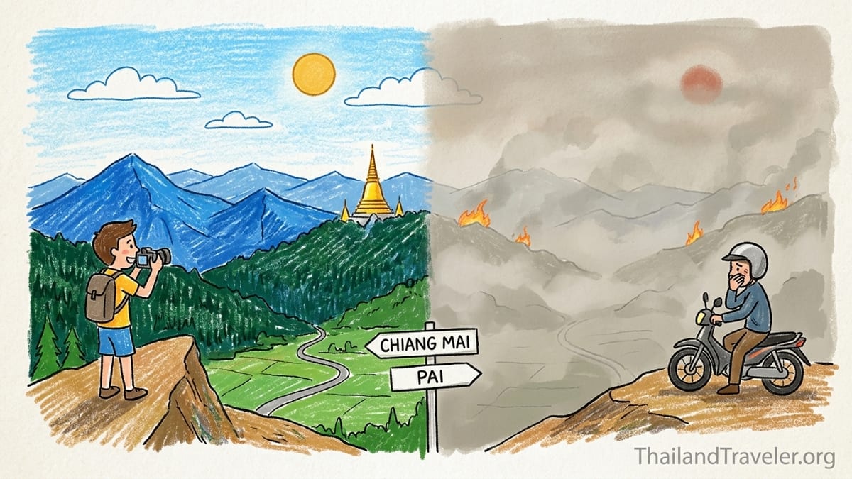
Mountain Scenery I Expected vs. What I Found
My trip to northern Thailand’s mountains ran from 18 to 29 March 2024, spanning Chiang Mai and Pai in Mae Hong Son province. I had booked months earlier from Europe, staring at glossy images of Doi Suthep’s temple floating above a crisp city skyline and Pai’s canyons lit by clear golden sunsets. Based on older guidebooks and Instagram posts, I pictured views stretching all the way to Myanmar from every high ridge.
Reality arrived as a slow, acrid shock. On my first afternoon in Chiang Mai, I checked into a small guesthouse near Nimmanhaemin Road and walked up to the rooftop. In the promotional photos, Doi Suthep dominated the horizon. In front of me, however, the 1,600 meter mountain was barely a silhouette. The sun glowed orange at 4 pm, as if it were already setting behind a thin curtain of smoke. My weather app showed “sunny,” but the sky was a uniform, metallic beige from horizon to zenith.
Two days later I rode the four-hour minivan to Pai. I had deliberately timed my stay for what I assumed would be “shoulder season” before Thai New Year, planning sunrise at Yun Lai viewpoint, afternoon hikes in the surrounding hills, and an overnight at a rustic bungalow overlooking the valley. Instead, the hills around the Pai River appeared washed-out and indistinct, even at midday. Locals told me this was “burning season” at full strength, something I had underestimated when I booked.
The gap between expectation and experience became clear when I compared my own photos to the adverts pinned up in my Pai guesthouse. Their posters showed deep-blue ridges stepping back for dozens of kilometers. My late-March shots from the same spots were dominated by a uniform grey gradient. It was not bad weather in the usual sense. It was the air itself.
What the Air-Quality Readings Actually Showed
I had heard of Chiang Mai’s so-called burning season before, but until I arrived I had treated it as background noise, similar to a vague “rainy season” warning. On 19 March 2024, my first full day in the city, I opened the official air-quality app from Thailand’s Pollution Control Department and then cross-checked IQAir’s data. Central Chiang Mai’s 24-hour PM2.5 average hovered around the equivalent of 150 to 180 on the US AQI scale, firmly in the “unhealthy” range, with hourly spikes higher in the afternoon.
These readings put fine particulate matter at several times the World Health Organization’s recommended daily limit. Recent analyses of northern Thailand’s dry season confirm that March is historically the worst month for PM2.5 in Chiang Mai, with monthly averages in recent years often around four to five times higher than relatively clean months like July or August. NASA and academic studies point to biomass burning as the dominant driver in this period, accounting for the majority of PM2.5 in April in Chiang Mai and nearby provinces.
In Pai, which sits further up the valley system in Mae Hong Son province, the monitors told a similar story when I checked IQAir’s historical data for the week of my visit. Daily PM2.5 averages frequently exceeded the “unhealthy for all” threshold. Local news at the time reported a sharp drop in tourist arrivals to Mae Hong Son during the haze, and shopkeepers in Pai told me several guests had cancelled last-minute after seeing live AQI readings.
Crucially, these readings also showed how conditions could diverge even within the north. On some days during my stay, Chiang Mai’s city-center AQI was slightly higher than Pai’s, while on others the smaller mountain town sat under the thicker smoke. That experience drove home a key point for planning. You cannot assume Chiang Mai’s reading will automatically be better or worse than Pai or Mae Hong Son, even though all share the same burning-driven haze season.
Mist, Low Cloud, or PM2.5 Haze: Learning to Read the View
At first glance, a hazy mountain photograph can look deceptively romantic. Before my trip I had seen pictures labeled “morning mist over Pai valley” that turned out, on closer inspection and date-checking, to be taken in late March during extreme smoke episodes. On the ground, I began to learn the difference between the softness of natural mist and the dullness of particulate pollution.
On my third morning in Pai, I rode a scooter to Yun Lai viewpoint before sunrise. Live AQI at the base of the hill read around the low 200s. From the top, I could see a pale blanket sitting in the valley, but there were none of the distinct, rolling cloud forms I associate with temperature inversion fog. Instead, the entire scene had a brownish tint. When the sun came up, it turned a muted red disc and climbed through the haze without ever casting sharp shadows. My eyes began to sting after fifteen minutes, something that never happens to me in ordinary mist or low cloud.
By contrast, a week earlier I had hiked in the hills near Chiang Mai during a brief spell of lower pollution, when 24-hour PM2.5 dipped closer to the “moderate” band. On that morning, patches of real low cloud clung to the forested slopes. The air smelled damp and earthy, not smoky. As the sun rose, the mist lifted quickly and the ridgelines snapped into focus with distinct layers and cool-toned colors. Those few clearer days provided a telling comparison. My lungs felt comfortable, and I finished a three-hour hike without the scratchy cough that became typical later that week.
That difference matters when you are interpreting photos online. Advertised images of “misty” ridges in March often show the flat, grey-beige palette of smoke, not the bluish atmospheric perspective of clean air. During my visit, I could rarely make out any texture in distant forest. The mountain shapes were simplified to ghostly outlines, and the horizon looked smeared rather than layered. Once I paired those visuals with the hard PM2.5 numbers in my apps, I became far less trusting of anything labeled simply “fog” or “haze” without context.
How the Smoke Changed My Days in Chiang Mai and Pai
The first thing I noticed was how the smoke flattened the entire landscape. From Chiang Mai’s Old City walls, the western horizon where Doi Suthep should have been felt oddly blank. On days when the 24-hour AQI edged near or above 200, visibility shrank to only a few kilometers. Hiking trails outside town lost much of their appeal because viewpoints that normally looked across a mosaic of rice fields and forest now stared into something resembling a grey curtain.
Outdoor comfort shifted just as dramatically. On what would normally be straightforward sightseeing days, I found myself ducking indoors to give my eyes and throat a break. After a half-hour walk around the moat one afternoon, with AQI readings in the “unhealthy” band, my breathing felt tight, like after standing too close to a bonfire. A friend with mild asthma who joined me on part of the trip needed to use her inhaler more often, and local pharmacists reported brisk sales of disposable masks and basic eye drops.
In Pai, the physical sensation of smoke was even more present because the town is smaller and more open to the surrounding hills. The air carried a constant woody smell. By evening my hair and clothes faintly echoed campfire. At Pai Canyon, I had planned a sunset walk along the narrow ridges. We went once anyway, but the experience was muted. The sun sank into a thick band of haze long before it reached the true horizon, producing a dull, orange glow rather than the classic gradient skies from the posters. Some other visitors left quickly, commenting that the views were “not worth the dust.”
Noise changed too. In Chiang Mai, you can sometimes track the burning season by the increase in sirens and the distant thump of helicopter rotors as crews monitor fires in the hills. I heard both during my stay. It reinforced the sense that this was not just an aesthetic issue for tourists but a regional environmental emergency playing out in real time.
Plans Changed: Cancellations, Shortened Hikes, and Indoor Days
Before leaving home I had booked several outdoor-heavy activities that assumed good visibility and tolerable air. These included a full-day trek near Chiang Dao, a sunrise photography session at a viewpoint above Chiang Mai, and two nights at a hillside bungalow outside Pai popular for its stargazing. Once I saw the AQI charts for my dates, I started canceling.
The Chiang Dao trek, planned for 22 March, required a two-hour drive north from Chiang Mai and would have kept us on exposed ridgelines for much of the day. The operator sent a pre-trip message acknowledging “heavy haze” and warning that views would be limited. Morning AQI readings in Chiang Dao town were similar to Chiang Mai’s, pushing into the 150 to 170 range. With that information, and knowing a family member in the group had mild bronchitis, we decided not to go. The company charged a 50 percent cancellation fee because we were within their seven-day window.
In Pai, I shortened my hillside bungalow stay from two nights to one after seeing updated forecasts and PM2.5 projections remain high. The property had a flexible policy and only charged me for the single night, but I still absorbed the sunk cost of transport and one pre-booked tour that I no longer wanted to take in that air. Instead of the planned half-day trek through surrounding farmland, we spent a long afternoon in an air conditioned cafe with portable air purifiers humming quietly in the corner, catching up on work we had hoped to leave behind.
Not every plan was canceled, but many were altered. Elephant sanctuary visits were trimmed from full-day to half-day experiences, with guides encouraging guests to spend more time in shaded areas and less time walking open trails. Cycling tours substituted shorter loops closer to town. Temple visits shifted to earlier in the morning, when AQI readings were often marginally lower, and mid-afternoons turned into de facto “indoor siesta” periods instead of exploration time.
What the Haze Cost Me: Financial & Practical Implications
Burning season did not just change the color of my photographs. It changed my budget. The Chiang Dao trek cancellation fee cost roughly the equivalent of a mid-range hotel night in Chiang Mai. Last-minute changes meant I forfeited one nonrefundable night in a Chiang Mai guesthouse when I decided to relocate south to the coast a couple of days earlier than planned to escape the worst of the smoke.
Transport changes add up quickly. Moving my domestic flight from Chiang Mai to Bangkok forward by two days incurred a change fee and a fare difference that together came to about the price of a nice dinner for two in a local restaurant. For some travelers these sums are manageable, but for backpackers on tight budgets they can feel significant, especially when compounded by additional nights elsewhere that were not originally planned.
Day to day, I also spent more on indoor comfort than I expected. Instead of street food picnics and long hours in parks, I retreated to air conditioned coffee shops, many of which had visibly installed air purifiers during recent bad seasons. Buying multiple drinks and snacks to justify a long stay raised my daily spending compared with what it would have been outdoors. In my guesthouses, I chose rooms with effective air conditioning and, where available, basic standalone filters, which cost slightly more than fan-only options.
The most frustrating expense, however, was psychological. I had invested time and money to see northern Thailand’s legendary mountain vistas and then paid again to not see them. That double cost is the key lesson I took away. In a region where PM2.5 can regularly reach “unhealthy” or worse from February through April, the real savings may lie in either visiting at clearer times of year or building enough flexibility into your bookings to pivot without penalties when the air turns bad.
Checking Air Quality, Choosing Dates, and Staying Flexible
After my trip, I spent time cross-checking my on-the-ground impressions with longer-term datasets from Thai monitoring stations and independent aggregators like IQAir. The pattern is clear. Northern Thailand’s haze issues concentrate in the late dry season, roughly February through April, with March and early April often the worst. Some years see pollution spikes already in January, while occasional storms in late April or early May can bring temporary relief. There is variation, but the risky window is consistent enough that it should shape how mountain-focused travelers plan.
For a return visit, I would divide my thinking into three seasonal bands. First, the “clear air priority” months. Historical data and local experience suggest that from roughly late May through early November, during the rainy season, PM2.5 levels in Chiang Mai and Pai tend to stay much closer to international guidelines on most days. Skies can be dramatic with afternoon thunderstorms and there is always a chance of rain, but on hikes I would far rather deal with mud and showers than smoke that infiltrates lungs and eyes.
Second, the “shoulder gamble” months of November, December, and early January. During this cool dry season, air is often crisp, especially in the mornings, and mountain views can be excellent. I have visited Chiang Mai in December on a separate trip and spent days with Doi Suthep sharply outlined against deep blue skies, AQI well into the “good” range. However, there are years when farmers begin burning earlier, and localized smoke episodes can appear. In these months, I would still go, but I would monitor conditions closely and book at least my mountain-heavy days with providers that allow late changes.
Third, the “avoid unless you are flexible and informed” months from roughly mid-February through late April. My March 2024 experience falls squarely in this band. I would not intentionally plan a once-in-a-lifetime mountain trip for these dates again. If I had fixed school holidays that only allowed travel then, I would treat northern Thailand as a backup rather than an anchor. I would book flexible accommodation in Chiang Mai and one other region of Thailand, such as the Gulf islands or parts of the Andaman coast that routinely show much lower PM2.5 in late dry season, and make my final choice a week or two before departure based on live air-quality data.
Whichever season you choose, the practical steps are similar. Check official Thai monitoring platforms together with independent services that aggregate multiple stations. Look at both city and nearby rural or high-altitude monitors rather than assuming one reading covers entire provinces. Check not only the day you arrive but the pattern over the previous two or three weeks. Where possible, choose hotels that allow changes up to two or three days before arrival and activity operators whose cancellation terms recognize that unsafe air is a valid reason to postpone trekking or high-exertion tours.
Health Considerations: Families, Sensitive Travelers, and Mask Myths
Throughout my trip I met travelers who shrugged off the smoke as “just haze” and others who were significantly affected. A couple from Sydney traveling with a five-year-old decided to leave Chiang Mai three days early because their child developed a persistent cough after several playground visits during high AQI afternoons. A retiree with chronic bronchitis I spoke with in a Chiang Mai pharmacy said he was cutting his usual three-month northern stay in half and spending more time near the sea.
Medical research on PM2.5 is unequivocal that sustained exposure to high levels of fine particulate pollution increases health risks, especially for children, older adults, pregnant people, and anyone with respiratory or cardiovascular conditions. Short-term visitors during a single bad week will not face the same cumulative exposure as residents, but that does not mean the impact is trivial. Headaches, throat and eye irritation, reduced exercise capacity, and poor sleep were common topics of conversation among tourists I met during the worst hazy days.
Masks can reduce some of that exposure, but only if used correctly. In Chiang Mai and Pai I saw a mix of surgical masks, simple cloth coverings, and properly fitted N95 or equivalent respirators. Only the last category is designed to filter a large proportion of PM2.5. Even then, their effectiveness depends on good fit and consistent wear. Many travelers I saw removed them for photos or because of heat, limiting their protective value. Higher altitude is not a guarantee of safety either. During my time in Pai, which sits at a higher elevation than Chiang Mai, AQI readings were often similar or worse than in the city. Smoke drifts and pools with wind patterns and topography, and mountain towns can be as affected as urban basins.
For families and sensitive travelers, the key is not panic but informed planning. If your itinerary is flexible, consider scheduling northern mountain segments for cooler or wetter months when PM2.5 typically drops. If you must travel in late dry season due to school holidays, build in options to retreat to regions with cleaner air on short notice. Pack at least a small supply of certified particulate respirators for each family member, but do not rely on them to transform “hazardous” days into safe moments for strenuous trekking. If live readings show very unhealthy levels, it is more sensible to postpone or relocate than to push on because a tour is nonrefundable.
The Takeaway
Looking back on my 18 to 29 March 2024 trip through Chiang Mai and Pai, my verdict is clear. Burning-season smoke fundamentally altered the experience of northern Thailand’s mountain landscapes and, in several cases, the viability of the outdoor activities I had planned. Views from iconic spots like Pai Canyon and city rooftops that showcase Doi Suthep were dramatically muted compared with the sharp, layered vistas I have seen in December and in wet-season gaps. My lungs and eyes reminded me daily that this was not simply “atmosphere” for moody photos but a real environmental stressor.
If your primary goal is enjoying sweeping mountain scenery, long hikes, and crisp air, the most enjoyable months are generally from around late November to mid-January and from roughly June through early October, accepting that the latter brings regular rain and the former can vary year by year. These seasons offer the greatest chance of combining clear views with tolerable temperatures and far lower PM2.5. Shoulder periods such as late January and early February can be rewarding but increasingly risky if burning starts early. They may suit repeat visitors who can tolerate some haze and adjust on the fly more than first-timers banking on postcard vistas.
The seasonal compromises are straightforward. If you choose to visit in the cooler dry months, you trade a small but real risk of early burning episodes for mostly excellent visibility and pleasant temperatures. If you favor the lush green of rainy season, you trade occasional storms and trail mud for cleaner air and fewer crowds at viewpoints. What I would avoid, for any mountain-centric itinerary, is pinning everything on late February through April unless you are prepared both mentally and financially to cut hikes, cancel treks, or abandon the region entirely if the AQI charts spike.
On my next trip to northern Thailand, I will treat burning-season months as a conditional option at best. I will watch PM2.5 data as carefully as I watch flight prices, choose fully flexible accommodation for any stay between mid-February and late April, and keep a Plan B in southern or central Thailand ready to go. The mountains around Chiang Mai, Pai, Mae Hong Son, and Chiang Dao are worth savoring, but they are at their best when you can actually see and breathe them. Sometimes, the sensible decision is not to power through the smoke but to wait for the air to clear.
FAQ
Q1. When is burning season in northern Thailand and how long does it last?
Burning season in northern Thailand typically runs from February through April, with March and early April often showing the highest PM2.5 levels. In some years light haze can appear as early as January or linger into early May, but the peak problem window is usually those three late dry-season months.
Q2. Is Chiang Mai always unsafe to visit during burning season?
No, conditions fluctuate from day to day and year to year, and some stretches within burning season see only moderate pollution. However, there is a significant chance that at least part of a February to April stay in Chiang Mai will coincide with “unhealthy” or worse PM2.5 readings, which can limit views and outdoor comfort. It is safer to plan flexible dates or choose another region if your timing is fixed.
Q3. Are Pai and Mae Hong Son less affected than Chiang Mai because they are smaller towns?
Not necessarily. During my March visit, Pai in Mae Hong Son province often recorded PM2.5 levels similar to or higher than Chiang Mai. Research and monitoring data show that much of the smoke comes from regional biomass burning rather than city traffic, so smaller mountain towns in the same airshed can experience equally poor or even worse air.
Q4. How can I tell if a photo shows mist or pollution in the mountains?
Natural morning mist and low cloud usually have a cool, bluish tone, with visible cloud shapes that rise and dissipate as the sun warms the air. Burning-season haze tends to be flat and beige or brownish, with the sun appearing as a dull orange disc and distant ridges reduced to vague outlines. Pairing the photo date with historical AQI data for that day can also reveal whether PM2.5 was high.
Q5. What tools should I use to check air quality before booking?
Use a combination of official Thai air-quality platforms, which report data from government monitoring stations, and independent aggregators that present PM2.5 and AQI values in real time. Check multiple locations, such as central Chiang Mai and nearby districts like Mae Rim or Chiang Dao, as well as mountain towns like Pai or Chiang Rai, to understand how conditions vary across the region.
Q6. If I have asthma or other respiratory issues, should I avoid northern Thailand entirely?
Not necessarily, but you should be especially cautious about timing. Consider scheduling your northern Thailand visit for months that historically show much lower PM2.5, such as much of the rainy season or early cool season, and keep a backup plan to relocate to cleaner-air regions if live readings deteriorate. Discuss your plans with a healthcare provider in advance and travel with any prescribed medications and a small stock of high-quality particulate respirators.
Q7. Do higher-altitude areas like mountain viewpoints have cleaner air during burning season?
Higher altitude does not guarantee cleaner air. During my trip, AQI readings at high viewpoints and in upland towns were often similar to valley readings. Smoke from regional burning can fill entire air columns over northern Thailand, so both valleys and ridgelines may sit inside the same polluted air mass.
Q8. Can I rely on masks to make outdoor trekking safe during bad haze?
Masks, especially well-fitted N95 or equivalent respirators, can significantly reduce personal exposure to PM2.5 but do not eliminate it. They also add heat and discomfort, which can be challenging on steep trails. In periods when AQI reaches very unhealthy or hazardous levels, the more prudent choice for strenuous outdoor activity is often to postpone or relocate rather than relying solely on masks.
Q9. What kind of booking policies should I look for if traveling in February to April?
Look for hotels and guesthouses that allow free or low-fee changes or cancellations until one or two days before arrival, and tour operators whose terms explicitly mention weather or environmental conditions as grounds for rescheduling. This flexibility can save substantial money if you decide to move south or shorten your time in the north because of sustained poor air quality.
Q10. If I can only travel once, which months would you personally choose for northern Thailand’s mountains?
Based on my March experience and previous clearer-season visits, I would target either late November to mid-January, when cool dry air often brings excellent visibility, or a window in the rainy season when I am comfortable with showers and trail mud. I would avoid planning a once-in-a-lifetime mountain-focused trip for late February through April unless I had full flexibility to reroute on short notice if burning-season smoke spiked.